Agoura Hills Search and Rescue Drone Recovery of Chuck M.
Missing Person Search in Agoura Hills, California
Advanced Drone Search Techniques Used to Locate Chuck M.
How AI Pixel Detection Improves Search and Rescue Outcomes
The Role of Drones in Modern Search and Rescue Operations
Providing Closure Through Professional SAR Drone Searches
How Advanced Drone Search and AI Mapping Brought Closure to a Family
In December 2025, I was contacted by the family of Chuck M., a missing man in the Agoura Hills area of Los Angeles County. For privacy reasons, he is referred to here as Chuck M.
Prior to my involvement, Los Angeles County Sheriff Search and Rescue had conducted two full days of ground search operations in the area. Despite extensive effort, Chuck had not been located. With time passing and concern growing, his family requested my assistance to bring in specialized search and rescue drone capabilities to supplement the work that had already been done.
On December 21, 2025, I located Chuck M. during my third day of searching.
Terrain, Visibility, and the Limits of Ground Searches
Agoura Hills presents a challenging search environment. The area includes steep mountain terrain, thick brush, and limited visibility from ground level. In conditions like these, even experienced ground teams can miss critical locations simply because of vegetation density, slope angle, and sightline obstruction.
This is where aerial search changes the equation.
Rather than relying solely on live visual scanning, I conducted structured drone mapping missions designed to collect comprehensive, overlapping imagery of the terrain. This method allows for detailed post-flight analysis and repeated review, which is often where discoveries are made.
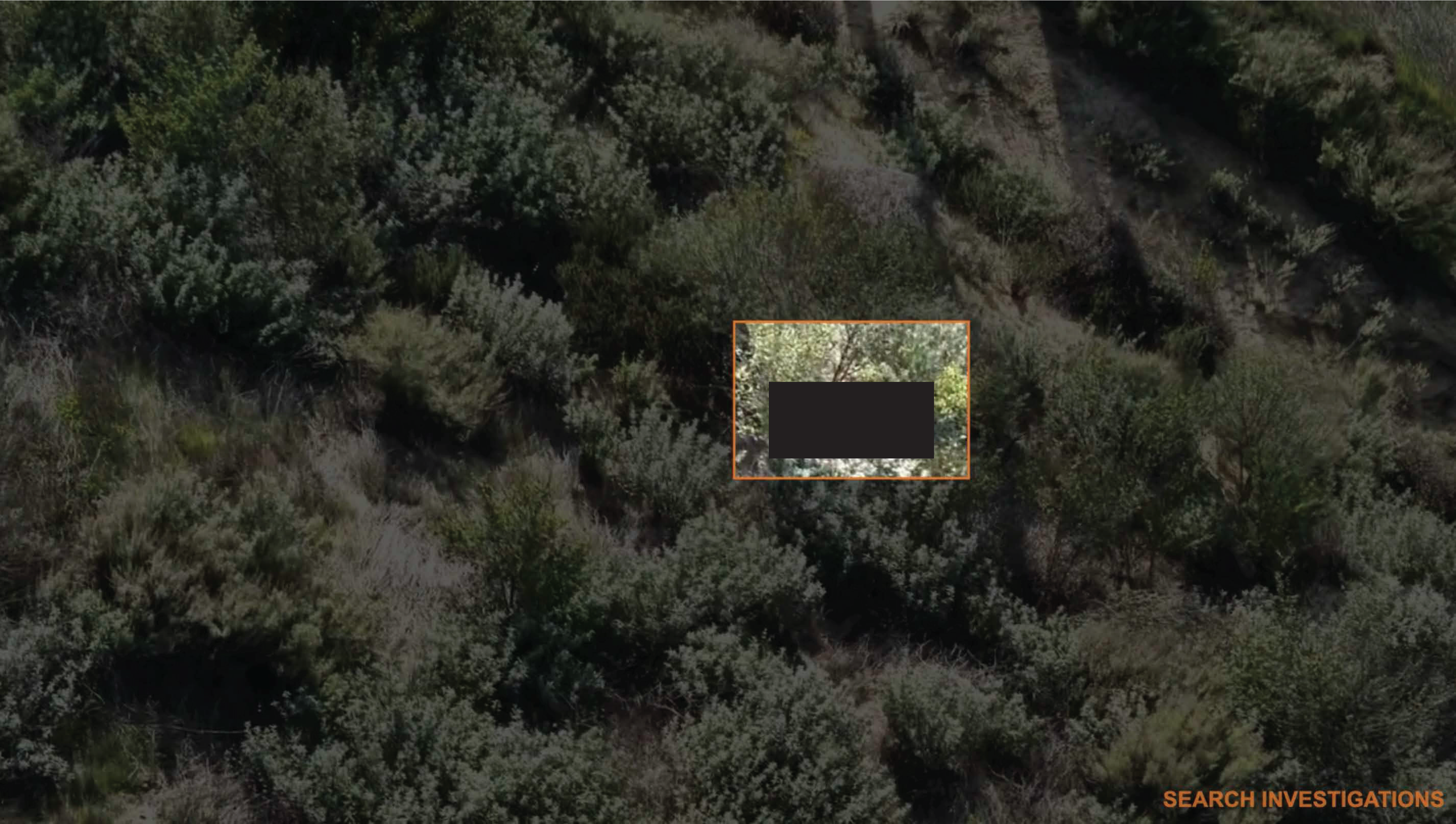
drone detection of missing man
Drone Mapping and AI-Assisted Detection
For this search, I deployed a DJI Matrice 30T, a public-safety-grade thermal drone platform specifically designed for search and rescue operations in rugged environments.
The aircraft captured high-resolution visual and thermal data across the mountain terrain. That data was then processed using pixel-detection and anomaly-identification AI software, including ADIAT and Eagle Eye Search.
These platforms do not guess or fabricate results. Instead, they analyze imagery at the pixel level, flagging anomalies that differ from natural surroundings. This can include:
Irregular shapes inconsistent with terrain
Color or texture contrasts against vegetation
Patterns suggesting human presence or disturbed brush
In this case, the software highlighted an area high on a mountainside, deep in dense brush. This was not a location that was easily visible or accessible from the ground and was not an obvious search area without aerial data.
After reviewing the imagery and verifying it through additional drone passes, I confirmed the location. Chuck M. was found deceased.
Why This Work Still Matters
These are the hardest outcomes in search and rescue. No one hopes to find a missing person this way.
But before Chuck was found, his family was living in a state of uncertainty. They did not know where he was, what had happened, or whether he was still out there alone. That uncertainty can be devastating.
By locating Chuck, his family was able to bring him home, lay him to rest, and begin grieving with answers rather than questions. Closure does not remove the pain of loss, but it does end the agony of not knowing.
The Critical Role of Drones in Modern Search and Rescue
This case illustrates why drones are no longer optional in modern search and rescue operations.
When used correctly by trained SAR professionals, drones allow teams to:
Search steep, brush-heavy, or dangerous terrain safely
Capture data that can be analyzed repeatedly and objectively
Identify areas missed by ground searches
Reduce time to discovery
Increase detection probability in complex environments
At Search Investigations, drone search and rescue is not a secondary service. It is a core specialization. Our work combines aviation, mapping, AI-assisted analysis, terrain assessment, and lost-person behavior modeling.
Proven Results and Leadership in 2025
The recovery of Chuck M. was not an isolated success. Throughout 2025, Search Investigations has been involved in multiple successful drone-assisted search and rescue recoveries across varied environments.
Our results come from experience, training, and disciplined methodology, not just technology. Owning a drone does not make someone a SAR drone operator. Effective search requires understanding terrain, data interpretation, probability of area, and how people move through landscapes.
Final Thoughts
Every missing person represents someone’s family, someone’s loved one, and someone who matters.
While we always hope for live recoveries, our responsibility is to conduct thorough, professional, and compassionate searches regardless of the outcome.
Chuck M. was found on December 21, 2025, because his family refused to give up and because advanced drone mapping and AI-assisted analysis provided a perspective that ground searches alone could not.
If sharing this story helps another family find answers or helps agencies understand the value of specialized SAR drone support, then it is worth telling.
If you are facing a missing person situation and need experienced search and rescue drone services in California or nationwide, Search Investigations is here to help. CONTACT US
Steve Fischer is the founder of Search Investigations, and is a licensed private investigator and a FAA licensed drone and aircraft pilot.